As the migration increased, the newcomers found much of the best land already claimed by speculators and their advance agents and surveyors. To secure the title, a land warrant was issued from Annapolis, which required a surveyor to lay out a tract. John Logsdon (1716-1797), whose base was his home in Westminster, surveyed much of what became the Taneytown area. Familiar with the countryside, the best land locations, and the areas already claimed, Logsdon operated as an advance agent for speculators, sometimes patenting lands jointly with them.
Many of these speculators were from the already-settled counties of southern Maryland. While the opportunities for speculation diminished near the Chesapeake Bay, the opening of the "backcountry" offered new possibilities after lowering the Indian threat, the construction of roads, and the influx of new settlers. In 1773, a young Charles Carroll of Carrollton (1737-1832) traveled to central Maryland, subsequently acquiring immense holdings for rent or sale. Another early speculator was John Digges (1697-1760) of St. Mary's County.
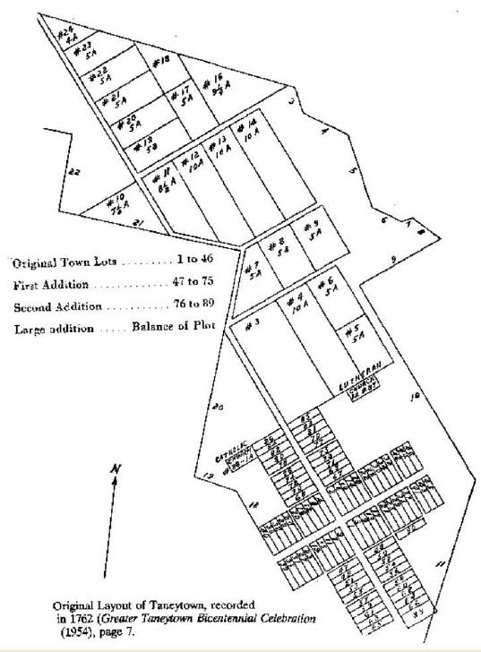
Digges eventually moved to the Conewago Settlement near McSherrystown, where he spent the rest of his life among Catholic co-religionists. Among the many tracts that he patented was a small, 60-acre tract near the future Taneytown along a path/road to Union Bridge called "Farquhar's Road." This was in the middle of a large block of unclaimed land. It was surveyed by John Logsdon and given the name "Brothers Agreement," a term made appropriate when Digges gave it to his son Edward (1719-1769) and his son-in-law, Raphael Taney (1732-1785). Incidentally, it was a frequent practice to stake out a claim to a small, strategic property to prevent others from moving in until the speculator was ready to take on the expense of paying a fee for a larger tract. In 1762, the two brothers-in-law had the tract re-surveyed to take in the unclaimed lands, giving the name of "Resurvey on Brothers Agreement" to a total of 7,900 acres.
In 1762, the first land sales on what later became York and Frederick streets were made in a new town along Taneytown's Monocacy Road. A persistent local legend states that the town was meant to center at the hilltop north of the square on York Street. No evidence has been found to support this claim.
It is not known whether Digges or Taney, Southern Maryland residents, ever visited Taneytown. Perhaps they did initially, but most of the time, they seem to have acted through a local land agent named Jacob Good. The lots were sold according to a standard pattern – half-acre lots lined the two cross streets. The buyer obligated himself to pay the regular dues to the Calverts, the taxes, and annual ground rent to the founder, his heirs, and assigns. The buyer was also obligated to build a house at least 20' by 24' with a brick or stone chimney within one year, subject to losing his land if he did not comply. Later building practices made some of the provisions obsolete. Around the edge of town were five to ten-acre outlets used for pasture or farming. As late as 1900, some of these were still used for those purposes but were eventually improved with dwellings.
York and Frederick Streets naturally developed more rapidly than did Baltimore Street and Emmittsburg Street (known in the 18th century as Second Street and in the early 19th century as Church Street). The development of those streets was helped by the growth of east-west traffic and the road from Westminster.
Part of the general development of east-west roads to carry traffic over the mountains was the formation of the Westminster, Taneytown, and Emmitsburg Turnpike Company in 1815. Although it went bankrupt before it was finished, it opened a new, more direct road from Westminster to Emmitsburg following today's Old Westminster Pike Road and Emmitsburg Road.
Digges and Taney divided their lands. In 1772, Taney sold the unsold lots, the right to ground rents, and 368 acres of the "Resurvey of the Brothers Agreement" to Jacob Good. After his death, Good's interest passed to his daughter, Mary, whose three husbands were named Thomas Boylan, John Gwynn, and Fredrick Crouse. The ownership of the ground rents passed to William G. Gwynn, who sold them to William B. Gwynn, who sold them to Israel Hiteshew. Eventually, the original rents were probably not worth collecting or were bought out by the lot owners.
A few travelers' accounts give a brief picture of the town as it appeared after the Revolution. In 1783, Johann David Schoepff (1752-1800), chief surgeon for the Ansbach regiment of the Hessian troops fighting for King George III, wrote of his travels south from Pennsylvania:
"The boundary between Pennsylvania and Maryland is shown by a broad line hewn through the woods. Tonnytown, a county town of perhaps 150 houses, was the first place in the province. There the road led us over Pipe Creek, which flows in a dry bed to the Susquehannock, the land on both sides being excellent …"
On July 1, 1791, George Washington noted in his diary:
"[Left Frederick about 7'o'clock] dined at one Cockerly's 13 miles off and lodged at Tawneytown only 10 miles further being detained at first by rain and to answer the address which had been presented to me in the morning. Tawneytown is but a small place with only the street to which the road passes built. The buildings are principally of wood … The lands over which we traveled this day are remarkable fine, but as was observed yesterday the fields are remarkable fine, but as we observed yesterday the fields are thinly covered with grain [owing to drought] The farmhouses are good mostly of stone and the settlers compact with good Barns and meadows appertaining to them."
Washington set out at 4 a.m. the next day. He noted the trees in the clearing on the border between Maryland and Pennsylvania were so grown up that he missed it. He commented that Taneytown and Littlestown were of a similar appearance, "but ye latter is more insignificant than the former."
In June 1789, Julian Ursyn Niemcewicz (1758-1841), a Polish poet touring America, came north from Frederick, spending the night in Taneytown. He wrote:
"... a so-called town, inhabited by Germans with 30 houses. The inn was very good and the dinner tasty, after the smoked meat of Frederick. The citizens sporting their national cockades read the newspaper Porcupine."
Niemcewicz spoke of the wild cherries lining the road north, eaten as picked from horseback. The land became poorer, sewn mainly in rye for whiskey.
This concludes part one in a yearlong series that will cover the chronological development of Taneytown and its citizens. Next week I examine the people and how they helped forge a new nation.
Read Part 2
David Buie is a Taneytown Resident who has a passion for
Carroll County and its place in history.
Read
other history articles by David Buie
Read other articles on Taneytown history