The map is being prepared with the assistance of the Adams County Office of Planning and Development. The borough is empowered to develop such a map under the Pennsylvania Municipalities Planning Code.
The purpose of official municipal maps is to plot a course for the development of public resources, such as trails, open space, and even roads.
The current draft was presented at this month's planning commission by county Planner Robert Thaeler, who routinely works on Fairfield Borough planning projects.
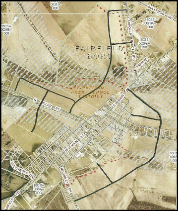
One of the key aspects reviewed at the meeting was the preliminary location of 'connector roads' that future developers might be asked to complete if the proposal is ultimately approved by the borough Council.
Two new arteries would include one that would take access off two points along Carrolls Tract Road and would culminate at two or three points along the western half of North Miller Street, and a second artery that would connect to East Main Street and continue to McGinley Drive.
The two roadways almost exclusively traverse undeveloped land that could, someday, be subject to development.
Also discussed were open space trails adjacent to stream corridors, and keeping them somewhat contiguous with those proposed in the Hamiltonban Township official map adopted by the township Board of Supervisors last year.
"We did look at the Hamiltonban map" Thaeler stated. "We tried to mesh (trail) connections. There is a reasonable consistency (with what the current Fairfield draft illustrates). Using open space along streams is consistent with Hamiltonban's."
While municipal official maps are more of a wish list than law written in stone, the state code does allow municipalities to use their official map as a bargaining chip when dealing with incoming, proposed developments to ensure that the development is contiguous with what exists and what resources the community wished to expand upon.
Since the current draft of the official map had just been submitted, the planning commission took no formal action at the meeting in order to allow time for the members to review the current proposal before their next meeting in March.


 (2/13) The Fairfield Borough Planning Commission continued their review of the draft of an official borough map at their February 10 meeting.